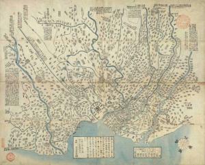
Illustration of the Outskirts of Tokyo Metropolis (Tōto Kinkō-zu)
originally published in 1825 (Bunsei 8) and revised in 1830 Tokyo Shiryō Collection 050-2
This is a guide published for sightseers coming to the Edo outskirts. To the east is the area in which the present day Kogane and Funabashi of Chiba Prefecture are located, to the south is where Haneda, Kawasaki City of Kanagawa Prefecture and Aoki Town of Yokohama City are located, to the west is Fuchu and to the north is where Omiya and Iwatsuki in Saitama Prefecture are located.
By the late Edo period, the number of tourists and people having pleasure trips coming not just to Edo town but also to the outskirts had risen. Because of this, this map adopts a standardized set of symbols to denote places such as famous spots and historic sites, shrines and temples, village names and the names of newly developed rice fields.
It is understood that there was a boom in going out on walks around the outskirts during this period as suggested by the following writing "Make a map of places to walk around without spending a number of days and avail those who like to a stroll". This map was revised in 1830 (13th year of Bunsei) and after this, beginning with 'The guide to famous places for flower calendar in Tokyo Metropolis' with its added flower calendar list, a number of similar maps of the outskirts were published and so, this shows how the surrounding areas of Edo were also being developed at this time.


